Products
-

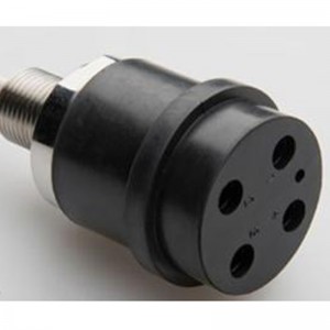
Pocket FerryBox
The -4H- PocktFerryBox is designed for high-precision measurements of multiple water parameters and constituents. The compact and user-customized design in a portable case opens new perspectives of monitoring tasks. The possibilities range from stationary monitoring to position-controlled operation onboard small boats. The compact size and weight facilitates this mobile system to be easily carried to the measuring area. The system is designed for autonomous environmental monitoring and is operable with either a power supply unit or a battery.
-
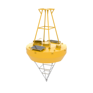
Frankstar S30m Multi Parameter Integrated Ocean Monitoring Big Data Buoy
The buoy body adopts CCSB structural steel ship plate, the mast adopts 5083H116 aluminium alloy, and the lifting ring adopts Q235B. The buoy adopts a solar power supply system and Beidou, 4G or Tian Tong communication systems, owning underwater observation wells, equipped with hydrologic sensors and meteorological sensors. The buoy body and anchor system can be maintenance-free for two years after being optimized. Now, it has been put into the offshore water of China and the middle deep water of the Pacific Ocean many times and runs stably.
-
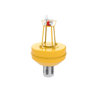
Frankstar S16m multi parameter Sensors are integrated ocean observation data buoy
Integrated observation buoy is a simple and cost-effective buoy for offshore, estuary, river, and lakes. The shell is made of glass fibre reinforced plastic, sprayed with polyurea, powered by solar energy and a battery, which can realise continuous, real-time and effective monitoring of waves, weather, hydrological dynamics and other elements. Data can be sent back in the current time for analysis and processing, which can provide high-quality data for scientific research. The product has stable performance and convenient maintenance.
-
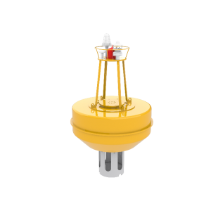
S12 Multi Parameter Integrated Observation Data Buoy
Integrated observation buoy is a simple and cost-effective buoy for offshore, estuary, river, and lakes. The shell is made of glass fibre reinforced plastic, sprayed with polyurea, powered by solar energy and a battery, which can realise continuous, real-time and effective monitoring of waves, weather, hydrological dynamics and other elements. Data can be sent back in the current time for analysis and processing, which can provide high-quality data for scientific research. The product has stable performance and convenient maintenance.
-

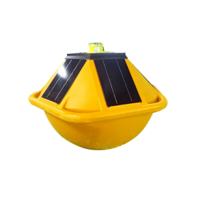
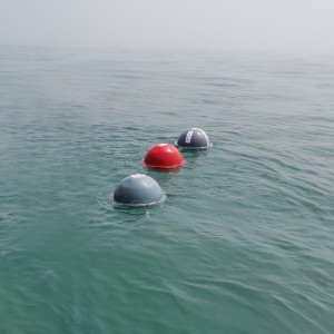
Drifting & Mooring Mini Wave Buoy 2.0 to monitor Wave & Surface Current Parameter
Product Introduction Mini Wave buoy 2.0 is a new generation of small intelligent multi-parameter ocean observation buoy developed by Frankstar Technology. It can be equipped with advanced wave, temperature, salinity, noise and air pressure sensors. Through anchorage or drifting, it can easily obtain stable and reliable sea surface pressure, surface water temperature, salinity, wave height, wave direction, wave period and other wave element data, and realize continuous real-time obse... -
Mini Wave Buoy GRP(Glassfiber Reinforced Plastic) Material Fixable Small Size Long Observation Period Real-time Communication to Monitor Wave Period Height Direction
Mini Wave Buoy can observe the wave data in short-term by the way of short-term fixed-point or drifting , providing stable and reliable data for Ocean scientific research, such as wave height, wave direction, wave period and so on. It can also be used to obtain section wave data in ocean section survey,and the data can be sent back to the client through Bei Dou, 4G, Tian Tong, Iridium and other methods.
-
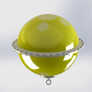
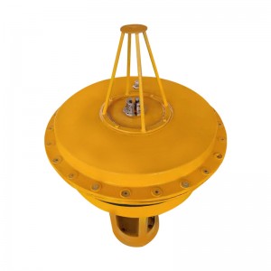
Mooring Wave Data Buoy (Standard)
Introduction
Wave Buoy (STD) is a kind of small buoy measuring system of monitoring. It is mainly used in offshore fixed-point observation, for the sea wave height, period, direction and temperature. These measured data can be used for Environmental monitoring stations to count estimation of the wave power spectrum, direction spectrum, etc. It can be used alone or as the basic equipment of coastal or platform automatic monitoring systems.
-

Oil Polution Tracker/ Oil Spill Detection Monitoring Buoy
Product Introduction HY-PLFB-YY drifting oil spill monitoring buoy is a small intelligent drifting buoy independently developed by Frankstar. This buoy takes a highly sensitive oil-in-water sensor, which can accurately measure the trace content of PAHs in water. By drifting, it continuously collects and transmits oil pollution information in water bodies, providing important data support for oil spill tracking. The buoy is equipped with an oil-in-water ultraviolet fluorescence probe... -
Disposable Lagrange Drifting Buoy (SVP type) to Observe Ocean/ Sea Surface Current Temperature Salinity Data with GPS Location
Drifting buoy can follow different layers of deep current drift. Location via GPS or Beidou, measure ocean currents by using Lagrange’s principle, and observe the Ocean surface temperature. Surface drift buoy supports remote deploy through Iridium,to get the location and data transmission frequency.
-
High Accuracy GPS Real-time communication ARM processor Wind buoy
Introduction
Wind buoy is a small measuring system, which can observe the wind speed, wind direction, temperature and pressure with the current or in fixed point. The inner floating ball contains the components of the whole buoy, including weather station instruments, communication systems, power supply units, GPS positioning systems, and data acquisition systems.The collected data will be sent back to the data server through the communication system, and customers can observe the data at any time.
-
Frankstar Wave Sensor 2.0 to Monitor Ocean Wave Direction Sea Wave Period Marine Wave Height Wave Spectrum
Introduction
Wave sensor is a completely new upgraded version of the second generation, based on the nine-axis acceleration principle, through the completely new optimized sea research patent algorithm calculation, which can effectively obtain the ocean wave height, wave period,wave direction and other information. The equipment adopts a completely new heat-resisting material, improving product environmental adaptability and greatly reducing the product weight at the same time. It has a built-in ultra-low power embedded wave data processing module, offering RS232 data transmission interface, which can easily be integrated in the existing ocean buoys, drifting buoy or unmanned ship platforms and so on. And it can collect and transmit wave data in real time to provide reliable data for ocean wave observation and research.There are three versions available to meet the needs of different users: basic version, standard version, and professional version.
-